Brian Mitchell
(A.M. Sullivan, The story of Ireland, Dublin 1867).
In Ireland as a prelude to a nationwide valuation of land and buildings, the so-called Griffith’s Valuation, the Ordnance Survey was directed to map the whole country at a scale of six inches to one mile. It was originally intended to accompany each map with written topographical descriptions for every civil (Church of Ireland) parish. The compilation of these ‘memoirs’ commenced in 1830. By the time the idea was abandoned in 1840, only one, the parish of Templemore, County Derry, was published. Each parish was meant to take up no more than six pages; Templemore, which includes the city of Derry, needed 350 pages and the £1,700 cost was three times the original budget for the whole county! Furthermore, the publication of Samuel Lewis’ two-volume A Topographical Dictionary of Ireland in 1837 weakened the case for the Memoirs. The field officers of the Ordnance Survey, however, did gather a wealth of historical and socio-economic information for many parishes in their notebooks.
All the original manuscripts are deposited in fifty boxes in the Royal Irish Academy in Dublin. They cover nineteen of Ireland’s counties: Counties Antrim and Derry contain by far the most detailed information with seventeen and twenty boxes, respectively. Counties Donegal, Down, Fermanagh and Tyrone account for two or three, whereas the remainder, Counties Armagh, Cavan, Cork, Galway, Leitrim, Leix, Longford, Mayo, Meath, Monaghan, Roscommon, Sligo and Tipperary have only one or part of one box each.
Emigration already a feature by the 1830s
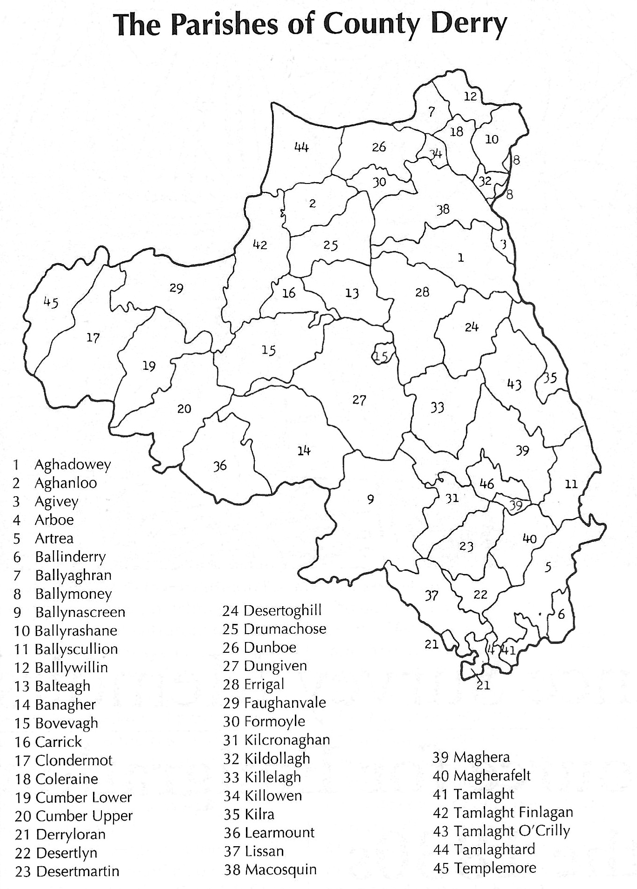
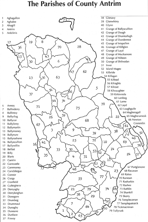
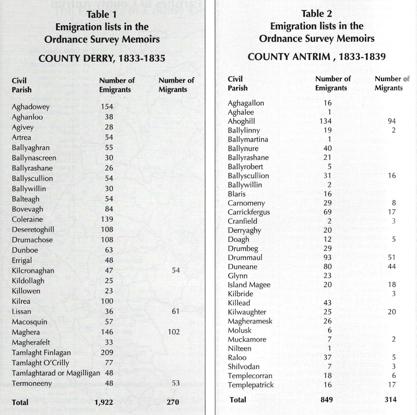
Although the Memoirs were compiled a decade before the Great Famine, emigration was already a very significant demographic feature which was commented on and recorded by the compilers. The Memoirs for Counties Antrim and Derry are unique in that for many of their parishes (maps 1 and 2) lists of emigrants were compiled for a brief period in the mid-to late-1830s. As emigration records these lists are unparalleled, identifying both the destination of the emigrant and their place of origin (townland address) in Ireland. In addition, the age, year of emigration, and religious denomination are given for each emigrant. The lists (table 1) for County Derry, in the years 1833-1835, record 1,922 emigrants and 270 seasonal migrants to harvest work in either England or Scotland. The County Antrim lists (table 2) for the years 1833-1839, record 849 emigrants and 314 seasonal migrants.
In many cases seasonal migration acted as a prelude to emigration rather than an alternative to it. The cheapness of travel between Ireland and Britain and between Britain and America encouraged ‘step-wise’ migration. An emigrant could walk to a seaport such as Derry, pay one shilling to cross the Irish sea, save a few pounds from harvest work in the Glasgow or Liverpool areas and, finally, buy a transatlantic passage.
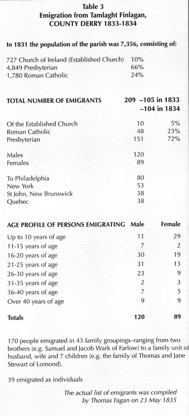
As table 3 illustrates the Memoir lists can provide data about how many people left each year, their age profile, and where they went. We can also use surnames to identify the number of apparently single unattached people leaving, and how many left in family groups.
Poverty not the only reason
The Memoirs provide a very clear insight into the nature of emigration in the 1830s. Nineteenth-century emigration from Ireland wasn’t just borne out of poverty. In Clondermot, County Derry, it was reported that many of those who emigrated were valuable members of the community, such as weavers, with a bit of capital behind them. In Ballynure, County Antrim, it was noted that, ‘the class of persons emigrating are mostly farmers, some of whom have taken capital (the price of their farm and stock) with them—one person last year took upwards of £500’.
In Ballylinny, County Antrim, two bakers emigrated in 1836 to Philadelphia with capital of £100 and £500. Of the twenty-nine persons who emigrated from Drumbeg, County Antrim, during 1835 and 1836 it was said they
were chiefly farmers who sold out their tenements in order to better their condition in another country, a few of them were employed in the bleaching business; both classes went on speculation of improving their condition, but not necessitated by any distress here.
In Drummaul, County Antrim, it was stated, ‘in this and in most districts, the industrious and well conducted are almost the only emigrants, while the able bodied idlers and disorderly characters are but rarely known to leave the country’.
Emigration was now becoming seen as the optimum course of action for those sons with no prospects of inheriting the family plot. In Camlin, County Antrim, the Memoir compiler reported:
the prevalence of emigration from this parish is probably owing to the circumstances of a farmer generally leaving his farm to his eldest son who is charged with a certain portion to each of the other children—the other sons having got a little capital usually emigrate.
Decline of domestic linen industry
The decline of the domestic linen industry and agricultural improvement were two factors behind emigration in these years. In Macosquin, County Derry, emigration had ‘increased since the decay of the linen trade’. In Desertmartin, County Derry, the Drapers’ Company who were attempting to improve their estate wouldn’t allow cottiers to reside on their manor. In Errigal, County Derry, ‘within the last four years eight families have gone to America in consequence of their land having been taken from them by the Marquis of Waterford who is enlarging the farms on his estate’.
In the parish of Coleraine the Memoir stated:
There is no emigration from this port: this is owing to there being no vessels of that class belonging to the port, which sail for the Colonies. In 1834, a vessel partly laden with passengers called on its way from Belfast, at Port Rush, to take passengers—fifty emigrants went on board, but on leaving the quay, the vessel striking on the pier, sprung a leak, and the passengers were again put ashore—For many years previous, nor since that period have any vessels called here for emigrants—Derry is usually resorted to by the people of the neighbourhood.
In Magherafelt the field officers noted:
Emigration varies very much, but certainly is decreasing from many causes—the principal and last of these was the cholera at New Orleans about three years ago when so many Irish were swept off. This has since materially damped the taste for emigration… Many who have gone from the neighbourhood of Magherafelt have realised large fortunes in New Orleans.
Emigrant letters
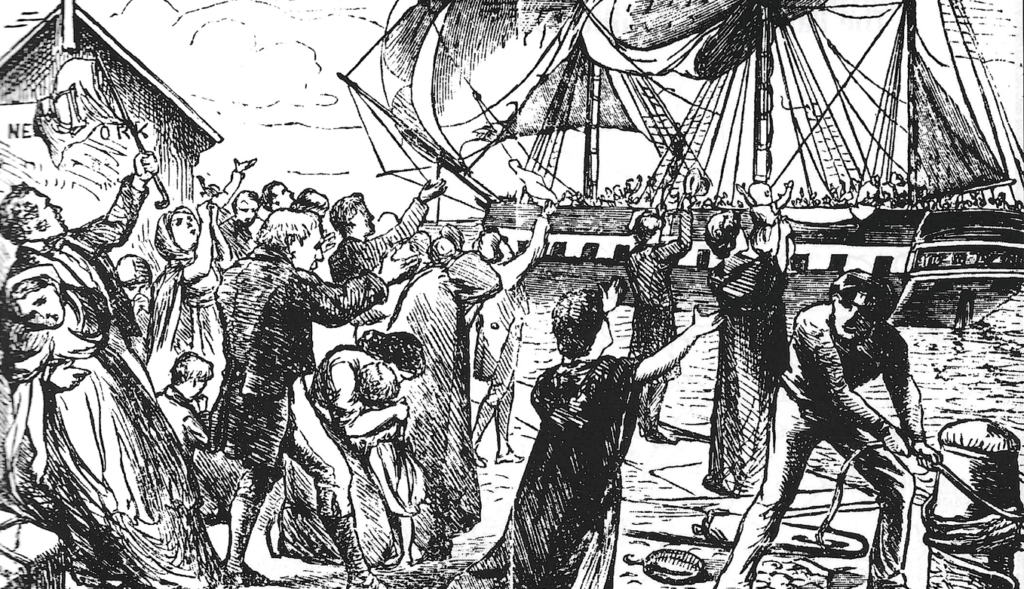
The ‘American letter’ (see HI Winter 1994) had an important role to play in the encouragement of the Irish to emigrate. The letter, with details of the voyage and of conditions in their adopted country, would have been read aloud to friends and to members of the family group. It played its part in changing the Irish attitude to emigration from one of resignation to one of acceptance and even of anticipation. These letters provide a fascinating insight into the nature of emigration. Three such letters were recorded in the Memoirs for Maghera, County Derry, one from a female, with the initials ‘M.D.’ and the others from a school master, with initials ‘F.D.’
Writing to his parents from Philadelphia on 12 August 1835 F.D. gives a harrowing account of his six week voyage from Derry. A south-westerly gale caused all sorts of havoc. You can almost imagine how relieved the passengers were to enter Delaware Bay on 7 June 1835:
After a disturbed sleep of about two hours we were awakened by the dash of a tremendous breaker that streamed like a torrent down every hatchway… Below the sounds were of a most disturbing character owing to some hundred tons of pig iron that was in the hold. Our ship lurched heavily on her side so much so that her mainchains were completely immersed in water… This lurching which I have described put in pretty quick motions all little articles that lay between the decks, and did not happen to be lashed firmly, so that pots, pans, delph, dayboxes, barrels, water bags and dirty buckets, all flew about with tremendous fury… Our ship was laid to and kept advancing backwards like mine Uncle’s old horse at the rate of one mile an hour.
It is understandable how a letter such as this would have dampened the enthusiasm of some would-be emigrants. In the Memoir for Dunaghy, County Antrim, it was reported:
About two years ago the Lady of the Lake passenger ship from Belfast to Quebec was wrecked on her voyage out—and out of twenty-five persons from this parish who were on board, only two escaped—This has ever since tended to discourage emigration.
In another letter to his uncle Daniel dated 9 July 1836 F.D. recognised there were opportunities in America for those who had none in Ireland. He had no regrets, despite his dislike of Philadelphia summers, about emigrating because he saw no prospects for himself in Ireland. F.D., however, felt
that the family that has a good comfortable way of living together or near each other at home that is in Ireland have more real heartfelt enjoyment in that home than they ever can have by coming to this country unless they can bring with them strength, firmness, much of determination and plenty of money to bear them in land and establish them on a farm. But our family early met with tyranny and misfortune. We were the children of circumstances and I think we did well to emigrate.
Clearly kinship ties were often seen as the only redeeming feature of nineteenth-century Ireland. This maintenance of kinship ties is a common thread running throughout 250 years of consistent emigration from Ireland’s shores.
The chain of kinship
Before the Famine the majority of overseas passengers seem to have travelled in some form of kinship group. The Ulster-Scots especially (see table 3) tended to emigrate as family units. After the Famine emigrant streams were dominated by lone emigrants, usually young and unskilled. They nevertheless moved along kinship paths. An older brother or sister might send back the cost of the fare to a younger relative. In time he or she might help bring another relative out of Ireland.
The Memoirs for the parishes of Clondermot and Faughanvale, County Derry, confirm that this trend was already evident in the 1830s. In Clondermot, the compilers wrote:
In most cases from one to three of the youngest, stoutest and healthiest of a family, without distinction of sex, emigrate together and send for the older members the following season under favourable circumstances… Two thirds had the expenses of their passage defrayed by earlier emigrants… The few who furnish their entire passage money themselves are only the respectable farmers, or individuals from whose families no emigration has yet been made.
In Faughanvale, it was said:
It is an usual system in this and other parishes to send out the younger members of a family first, to act as pioneers for the older. A constant correspondence is kept up, and each emigrant is generally furnished with his outfit by another who had gone before him.
The emigrant trade clearly depended to a large extent on people in the United States and Canada paying the fare to bring out family and friends. The selection of future emigrants lay largely with those who had gone before. Once emigration from a neighbourhood began it tended to be sustained by this chain mechanism.
Traditionally the port of embarkation for emigrants from Counties Antrim and Derry were Belfast and Derry respectively. A significant trend which was emerging in this period was the preference for Liverpool as the port of embarkation to North America. In Drummaul, County Antrim, the Memoirs note:
Spring is the usual season of embarkation—Belfast until the last two or three years was the port at which they embarked but Liverpool is the one from which emigrants from the north of Ireland now sail.
This only became feasible in the 1830s with the introduction of a regular steamer service between Irish ports and Liverpool.
In the 1830s, with the introduction of assisted passage, Australia became a new destination for intending emigrants. In Clondermot, the compilers noted that ‘Australian emigration is becoming more popular than at first, especially with females’.
It is clear that the Ordnance Survey Memoirs, particularly for Counties Antrim and Derry, offer a unique and fascinating account of emigration from Ireland in the 1830s. This material is of interest to researchers in the fields of family history, local history and academic study.
Brian Mitchell is co-ordinator of the Derry Genealogical Centre.
Further reading
J.H. Andrews, A Paper Landscape: The Ordnance Survey in Nineteenth-Century Ireland (Oxford 1975).
Ordnance Survey Memoirs of Ireland, Vols. 1-35 (Belfast 1990 onwards).